

Amy Johnson, Northumbria University
“How are you doing down there, Gopi?” A pair of white chinos and well-worn boots are all we can see of our colleague, Gopi Basyal, a geographer on the Sajag-Nepal team based at the Nepal Society for Earthquake Technology (NSET). At the moment, Gopi is hip deep in a precisely 1.2-meter hole. Or rather a soon-to-be 1.2-meter hole once he finishes scraping out the last few centimeters of earth at the bottom.
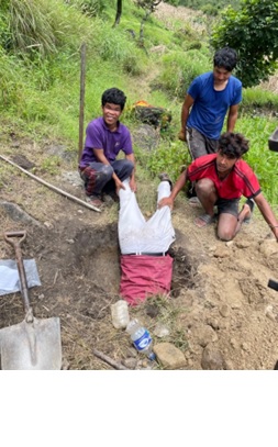
This particular hole is being dug in Kabre village in Myagdi district’s Annapurna rural municipality. It is part of Sajag-Nepal’s effort to document below-the-surface dynamics of hill slopes that can teach us more about the physical processes that activate landslides. Members of the Sajag Team met in Kabre at the end of the monsoon to complete the installation of slope monitoring equipment along a landslide prone section of the village’s hillside. Like many other slopes along the Kaligandaki river corridor and Beni-Jomsom Highway, those in Kabre move in the monsoon. But what are the thresholds for movement and why is not well understood at the level of an individual hillslope.
Yet, local level information is crucial because landslides in general are highly localized events. Small differences in soil composition, degree of a slope, and precipitation patterns can have big impacts on the probability of slope movement. To this end, Sajag-Nepal is conducting research on slope dynamics with local communities in four municipalities in Central and Western Nepal to produce evidence-driven landslide science for improved landslide susceptibility forecasting. Lowering Gopi into a hole was an important, if humorous, step in implementing the equipment needed to tell us more about the physical conditions under which a given slope moves.
Over September, I joined geographers and geologists from Durham University, Tribhuvan University, University of Bristol, and NSET and Research Associates from Social Science Baha as they worked with community members to install rain gauges, soil moisture sensors, and acoustic emission sensors at slope monitoring stations in Myagdi, Dolakha, Kavrepalanchok, and Sindhupalchowk districts. As an anthropologist, the technical details of how the equipment worked was not immediately obvious to me. But what was obvious was how the knowledge generated by the slope monitoring equipment interfaced with the knowledge community members had about conditions impacting landslides in their areas. In Kabre, community members were curious about how seasonal springs higher on the hillsides and newer permanent springs which had emerged after the 2015 earthquakes were interacting with monsoon rainfall to increase the likelihood of landslides in the village. Such detailed observations about the changing courses and timing of water movement above ground will be imperative to make sense of the information being generated below ground by the slope monitoring equipment. It is the team’s plan to meet again with community members in Kabre and other sites in the winter to share the initial data collected by the slope monitoring equipment. In collaboration with the community, we look forward to facilitating discussion about Kabre’s changing landscape, bringing together different forms of knowledges—above and below ground, geophysical and indigenous—to interpret the pace and progression of slope movement to better assess the probability of landsliding in the settlement. In this way, we are building a qualitatively nuanced and quantitatively rich framework for landslide forecasting, one hill, and one hole, at a time.
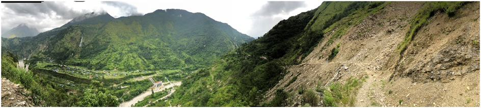
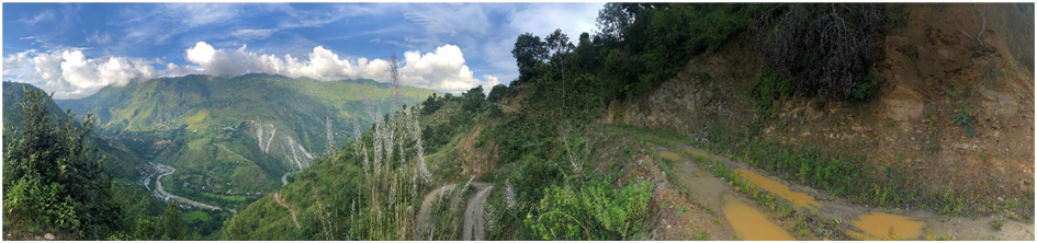
Nepal September fieldwork
For two weeks a group of social and natural scientists from Nepal and the UK undertook fieldwork in Myagdi and Temal, installing landslide monitoring equipment and interviewing households in our study sites. As well as making sure the equipment was correctly operating, we conducted 17 interviews, some close to two hours long. We are still digesting these interviews, but first impressions count.
Striking to me was the hierarchy of responses that households and individuals put in place to address their felt exposure to landslides. At one extreme, was the abandonment of villages by individuals, individual households, even whole settlements. Some interviewees could imagine their settlements becoming so risky as to be unliveable. But more common were fine gradations of response as households juggled the need to make a living with the landslide risk they faced. Households moved out of their homes during heavy rain to reside in safer locations; plant trees along the boundaries of their fields to stabilize the land; send their children to boarding school safely away from the settlement; appease deities; construct gabion walls to protect their homes; divert water; buy land in other (safer) locations; and move residence but within the village.
A second feature was the intersection between what people should do and what they could do. Time-and-again, respondents would express their concerns and worries about landslide risk, especially in Myagdi, but then say that their lives and livelihoods were spatially tied to these spaces of risk. Respondent #5 said: ‘Our land and properties are all here, so we cannot move’. Respondent #10: ‘Everyone is at risk from landslides; but everyone is earning from being here. The two go hand-in-hand.’ The government may provide funds to build new houses, but this did not address the need to make a living in place. The settlement of Bolde was abandoned by the whole population for four months following the 2015 earthquake. But in time, as the trauma of the event subsided and the need to make a living grew more acute, so the population drifted back: ‘What else could we do?’
A third thing that struck me was the almost seamless way in which respondents would move from the scientific to the cultural in their explanation of landslides. They said that cutting roads using heavy equipment destabilised the land. They worried about the lack of consultation and the failure of the authorities to ask local people about conditions in the area. They speculated that irrigating their vegetable crops might make landslides more likely. Respondents would also tell us, however, that under the rock and soil was water, and in the water a creature (a giant fish or snake) which when it moved caused the earth to shake and landslides triggered. This creature was disturbed by people behaving inappropriately, no longer following rituals correctly, or continuing with blood sacrifice. A 12th generation lama we interviewed in Temal likened the earth to the body: just as a person falls ills when the body ingests unclean things, so with the earth. When people behave inappropriately and destroy the environment, the earth responds.
Fourth, few if any of the households we spoke to could survive from in situ activities alone. In the most part, crops could feed families for six months or less of the year. Households were reliant, and increasingly so, on income generated in other places, not least overseas. While households often told us they could not – or would not – move given their reliance on place-based production, increasingly they were dependent on income generated elsewhere. This meant a marked change in labour availability and the demographic profile of the villages, with an ageing of the farm and village labour force. In Temal, respondents told us that two or three decades ago the hillsides were denuded of trees. Now they are clothed in vegetation. With less labour, land has been left fallow, even abandoned; livestock herds have declined resulting in less grazing of hillsides and common land; and LPG has replaced firewood as a cooking fuel. The hillsides are a ‘remittance landscape’ shaped by absence.
The big changes in people’s lives and repeatedly noted by our respondents were roads and the market access they afforded, and the improved availability of water and electricity. In connecting people, these changes have also contributed to a hollowing out of villages. There is little employment outside of farming, and farming is not enough. Opportunities in Nepal are limited, forcing villagers to leave their country as well as their villages. Government rural schools are poor, so families with ambitions for their children send them away. And prestige is accumulated by leaving. At the same time, natal households were tied to place even in the face of landslide risk.