
Support for emergency response planning by the UN humanitarian clusters – Round 2

Share This
1. Introduction
Overview
Sajag-Nepal is a UK-funded multidisciplinary research project examining the use of local knowledge and new interdisciplinary science to inform better decision making and reduce the impacts of multi-hazards in Nepal. The project involves a team of researchers and practitioners from Nepal, the UK, New Zealand, and Canada, including the UN RCO in Nepal. The research aims to make a significant difference to the ways in which residents, government, and the international community take decisions to manage, prepare, and respond to multi-hazards and systemic risks. A key objective is to establish a robust evidence-based approach to strengthen the national-scale strategic planning for complex multi-hazard events through the UN Humanitarian Country Team (HCT) cluster Emergency Response and Preparedness Plans (ERPPs).
Following a successful first round of engagement with the UN HCT clusters in April 2022, a second round of follow-up workshops was held in September 2022 to share the preliminary outcomes from the first round of workshops and to continue to explore how our risk models can be tailored to the specific needs of each cluster. The intent was to enable the Sajag-Nepal team to present and discuss a series of multi-hazard and risk models, and to explore the relevance and usefulness of these risk models with the clusters. The new knowledge generated will inform and tailor multi-hazard earthquake and monsoon scenario ensembles to guide the ERPP process. It is expected that this iterative process will result in a more robust and efficient ERPP framework.
Focus group arrangements
As part of Round 2 engagements the research team held semi-structured focus groups with the clusters to share results derived from Round 1. The design of the focus groups was based on thematic similarities, tasks, organisations, and actions undertaken by each cluster as part of their corresponding ERPP.
The groupings of the cluster along with the schedule is indicated in the table below. There was a total of 36 participants (29 men, 7 women) representing the 11 clusters.
| Clusters | Date | Time |
| Logistic & ETC | 14 September 2022 | 1000-1200 |
| CCCM & Shelter | 14 September 2022 | 1400-1600 |
| Health & Nutrition | 15 September 2022 | 1000-1200 |
| Food Security & Early Recovery | 16 September 2022 | 1000-1200 |
| Protection & Education & WASH | 16 September 2022 | 1400-1600 |
Each focus group began with a brief introduction of the Sajag-Nepal project and the objectives of the workshop from the work package lead, Dr. Tom Robinson. This was followed by a summary of the results from the Round 1 workshops and sharing of the initial risk model outputs, with a focus on anticipated risks due to monsoon rainfall. Participants were asked to focus on two main questions: (1) what format and type of information on risks due to monsoon rainfall would be most useful, and how would this be used to help plan? and (2) what new capacity or ability would the cluster gain from this information? The program was audio recorded and minuted with the consent of the participants.
Focus group summary
The workshops focused on identifying the most relevant spatial and temporal resolutions for understanding monsoon-related impacts, as well as the types of information needed by each cluster. Each workshop was divided into two sessions as indicated below.
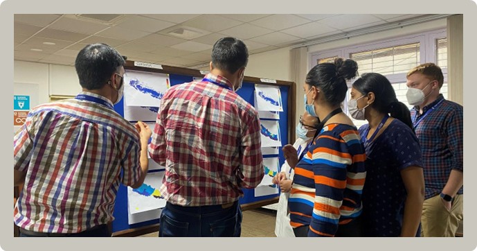
Risk modelling sharing and discussion
In the first session, the team presented examples of national-scale maps showing anticipated monsoon-related impacts, or relative risk, for different infrastructure at a range of different resolutions. In terms of spatial resolution, three different resolutions were shown:
- relative risk to individual buildings or roads;
- relative risk aggregated by district; and
- relative risk aggregated by province
Similarly, three different temporal resolutions or lead times were presented for forecast rainfall:
- seasonal (~3 months);
- fortnightly (14 day); and
- 72 hours
This led to open round table discussion on what type of information and time scale would be most useful for each cluster. Most of the clusters indicated that risk information based on the seasonal forecast would be useful for preparedness planning, whereas fortnightly and 72 hr information would be valuable for immediate response including readiness (e.g., local capacity and supply) and relocation. Regarding the spatial resolution, some clusters preferred to have relative risk information at the building scale, irrespective of the uncertainties, as compared to the lower-resolution aggregated models. Importantly, some clusters suggested that district-level rather than provincial-level risk information was inherently more useful because suitable structures for disaster response already exist at the district level but are still being developed by the provincial governments. Others, however, noted that provincial-level information was preferred as this better matched with pre-monsoon contracting and response planning.
In terms of temporal resolution, the inherent uncertainty in risk estimates based on a (relatively) low-confidence seasonal forecast was acceptable among the clusters because this information was seen as primarily useful for planning rather than direct response. In contrast, multiple clusters highlighted the potential usefulness of risk information based on the fortnightly or 72 hr forecasts for humanitarian response. They also highlighted the importance of precise spatial data (i.e., at the level of individual buildings) for planning response and evacuation and also for communicating the risk to the government and community. Some clusters drew distinctions between fortnightly and 72 hr forecasts, arguing that the former would allow sufficient time to build up capacity and supplies as well as identify potential relocation sites, and therefore are more useful.
Participants cautioned, however, that uncertainties in the risk modelling could create trust issues if there are repeated mismatches between anticipated impacts and actual events, both among local populations and the humanitarian community. Regarding the possibility of adjusting the ERPPs based on fortnightly or 72-hour forecasts, almost all clusters indicated that decisions on these shorter time scales were more focused on mobilisation of resources and anticipatory action. Thus, timely information on the possible impact areas and risks would still be valuable but would not necessarily lead to changes in the ERPPs.
Some clusters, reflecting their specific focus and area of responsibility, identified the importance of moving beyond buildings or roads to estimate relative risks to other types of infrastructure – such as schools or health posts. The team clarified that any infrastructure can be included in the model as per the need of the cluster so long as suitable location and vulnerability data are available. Each cluster was then asked to indicate the infrastructure that would be more relevant to their clusters to include in the model.
Voting session
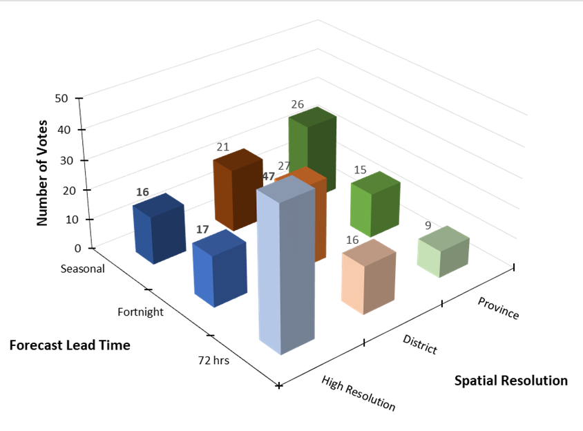
The purpose of the second session was to capture a semi-quantitative record of the previous discussion and to map out the spatial and temporal resolutions of risk information that would be most useful for each cluster. Each participant was provided with six sticky dots to vote for their preferred combination of temporal and spatial resolutions which would be most appropriate for the creation of their cluster ERPPs. After the round of voting, the cluster members were further asked to elaborate on the reason for their votes and to indicate why and how these combinations of spatial and temporal resolution would be useful for their work as a cluster.

The voting showed a clear preference for anticipated risks from seasonal forecast information to be aggregated at provincial scale while those from shorter-term forecasts were preferred at a more local scale, as shown in the summary figure below. The emphasis on seasonal forecasts at the largest spatial (provincial) scale likely reflect the fairly low certainty but long lead time (3 months or more) of the seasonal forecast information; such information cannot reliably be used to pinpoint specific areas that are likely to be affected but could be used to prioritise planning and preparation in one or more provinces compared to others. In contrast, anticipated risk based on fortnightly, or 72-hour forecasts was seen to be potentially useful at the scale of districts or individual buildings, with some clusters noting municipalities as a potentially useful resolution. Participants generally wanted risk estimates across all temporal resolutions (seasonal, fortnightly, and 72 hrs) but were happy to have lower spatial resolution (provincial) for the seasonal forecasts, preferring higher spatial resolution (building-scale) for the 72-hour forecasts.
Conclusion and next steps
The focus groups were valuable for understanding the preferences of the clusters, especially on the combination of spatial and temporal risk estimates that can be incorporated into their respective ERPPs. They also provided insight into the additional infrastructure elements that could be included in the risk model. The research team will use this information to refine a set of multi-hazard scenario ensembles and consequent relative risk estimates, in order to generate the scientific evidence to support each cluster in preparing improved ERPPs. Based on the discussion and exercise sessions, risk modelling outputs that could be used in the next monsoon ERPP will be generated and presented at a series of follow-up workshops in spring 2023. The end goal is to develop the multi-hazard scenario ensemble to the point that it can underpin a robust and effective ERPP framework.